Taiwan is located on the Circum-Pacific seismic belt. It is well known that seismicity of the Taiwan area is very high. As such, safeguarding lives and property from the destructive effects of earthquakes is a major concern of the people in the region. The damaging effects of earthquakes are primarily caused by strong ground shaking. Reduction of life and property losses from strong ground shaking require conscientious application of construction codes and earthquake resistant design, enforcement of adequate land-use policies as well as implementation of appropriate retrofits measures. The implementation of these mitigation measures must be based in large part on the recordings from large earthquakes. Such data are crucial for designing earthquake resistant structures and understanding the source mechanism of earthquakes and the propagation of seismic waves from source to site, including the local site effects. The last several years have seen an amazing growth in strong motion seismology. The most important work was setup the very dense strong motion observation network in Taiwan area, including free-field and downhole stations. The strong motion network in Taiwan includes SMA-1 network, SMART II, TSMIP, LSST network, and downhole arrays in the Taipei Basin. These data provide an excellent opportunity to study the source, path, and site effects on the ground motions. Nonlinear soil response analyzed from the observed records have very interesting results. Other research activities such as numerical modeling, physical modeling etc. also grow up quickly during the past several years.
SMA-1 network:
An island wide strong motion network, which includes 109 accelerographs, is operated by the Institute of Earth Sciences, Academia Sinica (IESAS) since 1974. First strong motion record by this network was in April 1976. The purpose of this network is mainly for studying the earthquake source, structure responses, the attenuation of ground motions and risk analysis. Accelerometers include 48 analog and 61 digital recording system. Most of them are installed on free-field site, but also has some are on the manmade structures (Chian et al., 1991; Chiu et al., 1992; Huang et al., 1994)
[Operated by: IESAS, http://www.earth.sinica.edu.tw]
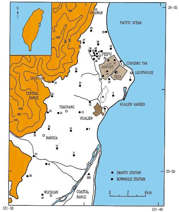
Fig1. The location and configuration of the SMART-2 array including 40 free-field stations and two downhole vertical arrays
SMART II:
After the succeeded and well-known SMART-I array in Lotung, which closed at the end of 1990. A new strong-motion array named SMART-II (Chiu et al., 1994) is deployed by IESAS in the city of Hualien and its vicinity since December 1990, and fully operated in 1992(fig 1). This array consists of 45 surface stations cover a region of 110 km2. The borehole accelerometers installed at Peipu and the marble plant in Meilun Industry Park. All sensors used in this array are force-balance accelerometers. The recording units have 16 bits' resolution. Each recorder is equipped with two megabyte memory and GPS. For a surface station, the accelerometer is anchored on a concrete pad (120cm*120cm*10cm). Accelerometer and recorder are well protected by a FRP shelter. This array is designed for both seismological and engineering purposes.
[Operated by: IESAS, http://www.earth.sinica.edu.tw]
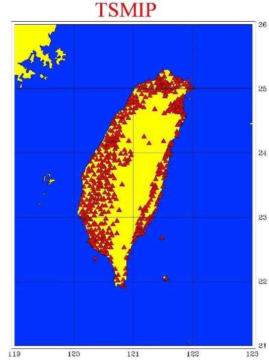
Fig 2 The location and configuration of the TSMIP
TSMIP:
Taiwan Strong Motion Instrumentation Program (TSMIP) is a six-year plan from 7/1/1991 to 6/30/1997, executed by the Seismological Center, Central Weather Bureau (Shin, 1993; Liu et al., 1994; Kuo et al., 1995; Wen et al., 1995). The program installed up to 600 digital free field strong motion instruments(fig 2), and 400x3 digital channels of strong motion monitoring systems in nine metropolitan areas. The main purpose of this program is to study the characteristic of ground motion at different geological conditions, and the response of different type man-made structures (Building Array). All results can be applied to improve the design spectrum and building codes of current use. Each strong ground motion station has the same design. A small fiberglass house covered on a concrete plate. The strong motion instrument is a force-balance accelerometer. It has 16 bits' resolution, can record the ground motion up to 2g. All stations have AC power. When the power system shutdown by earthquake or other problem, the DC power of the recording system still can operate about 4 days.
[Operated by: CWB, http://www.cwb.gov.tw]
LSST network:
The Lotung Large Scale Seismic Test Program (LSST) is a joint project between the Taiwan Power Company (Taipower) and the Electric Power Research Institute (EPRI). The Institute of Earth Sciences (IES), Academia Sinica, is a contractor of Taipower to perform instrumentation installation and maintenance, and data collection, reduction and analysis. By the end of October 1985, all instruments were installed by the engineers of IES and successfully commissioned by the engineers of manufactory.
In the initial phase of the instrumentation, four types of gauges were installed in the field for data acquisition. They are surface accelerometer, downhole accelerometer, structural response accelerometer and interfacial pressure transducer. Except pressure transducer, all others are triaxial strong motion accelerometer. The outputs of all accelerometers and pressure gauges are transmitted by hard wire to the central recording device. LSST1 closed at the end of 1990.
To record the near-field ground motion for an earthquake, a potential site was selected at Hualien Veteran's Marble Plant as being promising site for the deployment of LSST2 in eastern Taiwan. There are two models deployed in LSST2. One is the 1/4-scale cylindrical containment model and another is the cylindrical liquid-storage-tank model which away 40 meters from the containment model. The former started in September 1993 and the latter started in September 1995. In this phase of the instrumentation, fifteen surface accelerometers, twelve downhole accelerometers and fifteen containment structure response accelerometers were installed in cylindrical containment model for data acquisition. All stations are instrumented witha three-component force-balance accelerometer. On the other hand, the cylindrical liquid-storage-tank model consists four three-component accelerometers and nineteen one-component accelerometers.
[Operated by: IESAS, http://www.earth.sinica.edu.tw]
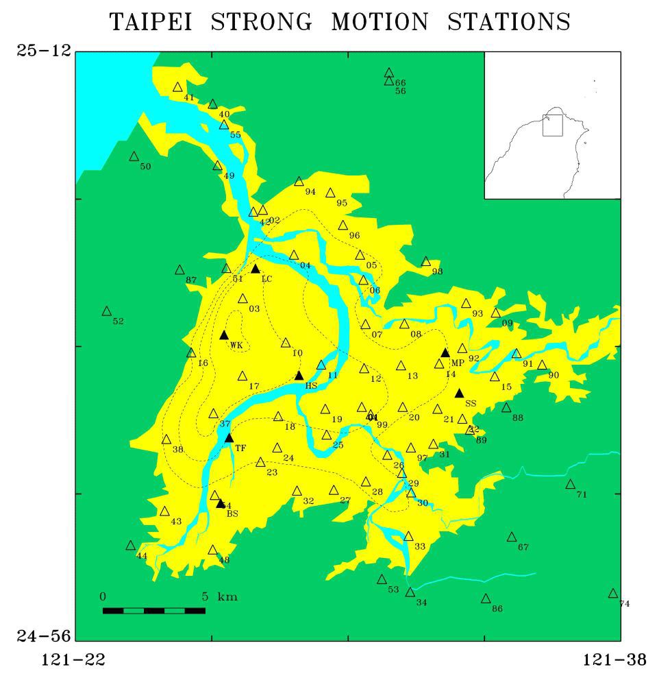
Fig 3 Locations of the strong motion stations in Taipei basin. Open triangles show the TSMIP network in the Taipei area. Solid triangles denote the positions of downhole array sites.
Downhole arrays in the Taipei Basin:
For the purposes of engineering construction, underground water management, ground subsidence prediction, study of the basin effects of seismic waves, and geological sciences, a five-year plan is proposed from the Integrated Survey of Subsurface Geology and Engineering Environment of the Taipei Basin. This research project conducted by the Central Geological Survey, Ministry of Economic Affairs since August 1991. Among the plans, the IESAS was entrusted with the study of the basin effects on seismic waves (Yeh et al., 1994; Wen et al., 1994, 1999). This project proposed the installation of downhole accelerometer arrays in the Taipei Basin (DART) one site per year to analyze the variation of seismic waves propagated from basement to ground surface. The instrument installations were finished in the site of Sewage Disposal Plant of Wuku Industry Area (WK), Panchiao Water Conservancy Bureau (BS), Panchiao Committee for Retired Servicemen (TF), Water Pump Station in Luchou (LC), Chunghsin Bridge (HS), Sungshan cigarette factory (SS), and Mingchuan park (MP)(Fig 3). Each site includes one free surface accelerometer and some downhole sensors. These force-balance accelerometers connect to a PC-based central recording system or K2 digital recording system with GPS providing timing and position information.
[Operated by: IESAS, http://www.earth.sinica.edu.tw]
Reference:
Chian, C. C., T. Y. Hou, C. C. Liu, and Y. T. Yeh (1991). Observation report of the strong motion station at Liyutanreservoir, Open-file report of the IESAS.
Chiu, H. C., S. D. Ni, H. C. Huang, C. C. Liu, C. Z. Lin, and Y. T. Yeh (1992). Effects of the Canyon topography and the dam site behavior under the strong earthquake - (I) Installation and testing report of the strong motion seismometer, Institute of Earth Sciences, Academia Sinica, Open-file Report IESCR92-002.
Chiu, H. C., Y. T. Yeh, S. D. Ni, L. Lee, W. H. Liu, G. F. Wen, and C. C. Liu (1994). A new strong-motion array in Taiwan : SMART-2, Ter. Atm. Oce., 5, 463-475.
Huang, C. F., L. Chiang, C. C. Tsai, T. Y. Hou, W. S. Liu, and C. C. Liu (1994). Strong-motion observations around the Liyutan reservoir area, Taiwan, Institute of Earth Sciences, Academia Sinica, Open-file Report, 27pp.
Kuo, K. W., T. C., Shin, and K. L. Wen (1995). Taiwan strong motion instrumentation program (TSMIP) and preliminary analysis of site effects in Taipei basin from strong motion data, in Urban Disaster Mitigation: The Role of Engineering and Technology, Edited by F. Y. Cheng and M.-S. Sheu, Elsevier Science, 47-62.
Liu, K. S., T. C. Shin, W.H.K. Lee, and T. B. Tsai (1994). Taiwan strong-motion instrumentation program ? The characteristic comparison of free-field accelerographs, Meteorological Bull., Central Weather Bureau, 39, 3, 132-150.
Shin, T. C. (1993). Progress summary of the Taiwan Strong Motion Instrumentation Program, Proc. of the Symposium on Taiwan Strong Motion Instrumentation
Wen, K. L., Y. T. Yeh, and Y. H. Yeh (1994). Study of basin effects on Seismic wave (I), Central Geological Survey, Ministry of Economic Affairs, Report 83-018.
Wen, K. L., H. Y. Peng, L. F. Liu, and T. C. Shin (1995). Basin effects analysis from a dense strong motion observation network, Earthq. Eng. Struct. Dyn., 24, 8, 1069-1083.
Wen, K. L., Y. T. Yeh, C. C. Liu, H. Y. Peng, L. F. Liu, and C. F. Wen (1999). Study of the basin effects on seismic waves, Special issue for the subsurface geology and engineering environment of Taipei basin, Spec. Publ. Central Geological Survey, No. 11.
Yeh, Y. T., K. L. Wen, and Y. H. Yeh (1994). Study of basin effects on Seismic wave (I), Central Geological Survey, Ministry of Economic Affairs, Report 83-004.
